Best Places to Scuba Dive in WNY

Most people associate scuba diving with crystal clear waters, schools of colorful fish, and tropical destinations. In reality, though, there is much more to the sport than that. The numerous lakes, springs, rivers, and sinkholes often available to divers right at their doorstep offer some fantastic sites with amazing landscapes and cool critters to discover.
The WNY area, for instance, is famous for its world-class shipwreck dives. Two of the Great Lakes, Lake Erie and Lake Ontario, touch state boundaries and had ship traffic for nearly 400 years. That’s 400 years of wrecks, many of which are perfectly preserved having sunk in fresh and relatively cold water.
The Niagara River and Finger Lakes also have some great dive sites that attract both local divers and visitors from around the world. So let’s take a closer look at some of the best places to dive around the Western New York area.
Lake Erie Wrecks
Acme
Latitude: 42° 36' 36.2412" N
Longitude: -79° 29' 51" W
Depth: 130 ft (40 m)
Average Visibility: 20-60 ft (6-18 m)
Entry Type: Boat
Difficulty Level: Advanced
There are two shipwrecks with the name Acme in Lake Erie. The one we are going to talk about in this article was a 190 foot long steam powered package freighter built in 1856 by George Hardison of Buffalo. What’s interesting about this ship is that it had two hogging arches that went alongside the vessel from bow to stern for structural support.
On the day of its sinking, November 4th, 1867, Acme was carrying a cargo of beef, flour and cow hides. However, nearing the Buffalo shores, the ship encountered a fierce gale. It began taking on water, and was soon consumed by the lake. The crew abandoned the ship on lifeboats. All hands survived.
Photo by Vlada Dekina
Today, Acme lies upright in about 130 feet of water. Although the wreck is silted up to its gunwales and deck, the large hogging arches rising a dozen feet above the lake floor are spectacular. The ship’s cabin was blown off during the sinking, exposing the boiler and steam engine. Almost nothing, save a few planks of wood, is left of the stern, but the bow is slightly more intact, including the large winch. All in all, the wreck is definitely worth visiting at least once. Note, there is sometimes a current at this site.
Alabama
Latitude: 42° 52' 23.7612" N
Longitude: -78° 54' 43.2" W
Depth: 35 ft (10.7 m)
Average Visibility: 20-50 ft (6-15 m)
Entry Type: Boat
Difficulty Level: Novice
The Alabama was a 254-foot wooden side-wheel steamer, built in 1848 as a luxury liner. Due to the rapid development of shipbuilding at the time, the vessel became outmoded in just a few years and was relegated to carrying anything and everything it could get ahold of. During its operation Alabama has suffered a few collisions and a number of mechanical issues. On August 29, 1854, the ship was on its way to Ohio to have some repairs performed. However, only a mile and a half off the Buffalo Harbor an unfortunate event happened - the water put out the boiler fires. The ship sank within minutes. Luckily, all the crew made it off safely.
Several attempts were made to raise or move the ship. When all of them failed, however, the demolition crews ripped the wreck of Alabama apart to make navigation safer.
In 1980 the wreck was rediscovered by Jack Messner as a diving spot. Although the remains of the ship are broken up and little is left to be seen, the wreck is still worth visiting, especially if you are looking for a relaxed, shallow dive.
Betty Hedger
Latitude: 42° 25' 7.0788" N
Longitude: -79° 36' 32.1012" W
Depth: 115 ft (35 m)
Average Visibility: 30-70 ft (9-21 m)
Entry Type: Boat
Difficulty Level: Advanced
The Betty Hedger, also called the Sulfur Barge, was a 113-foot vessel built in 1927 in Kingston, NY and was operated by the New York Scow Corporation. The barge’s primary job was delivering sulfur to the industries in the area. On November 2, 1937 she, along with three other barges, fully loaded with sulfur, were in tow of the tug Ballenas (the most powerful tug on all the great lake at the time). The ships were on their way from Buffalo to Cleveland when they encountered a powerful storm. The mighty tug quickly sent out a distress signal and the Coast Guard from Erie, PA, removed all eight crew members from the four barges, preventing any loss of life in the incident. The three of the four barges broke loose in the storm and were later recovered. Although the Betty Hedger remained under tow for a time, she couldn’t reach the safety of Erie, PA and at some point sank into the lake a few miles east of Barcelona, NY.
The remains of the Betty Hedger lie in 115 feet of water, with mounds of sulfur cargo still in place, dominating the center of the wreck. The entire structure appears to have a “T” shape when viewed from the front. Much of the decking and sides are gone, leaving the massive framing structure exposed.
There are many small details that make this wreck truly worth a visit. While exploring the Betty Hedger, divers can check out bits and pieces of machinery straight out of the Roaring 20s, including a small pilot house, a running light, an anchor, and a winch. What’s more, you can even peek inside the wreckage through the portholes on the side of the barge.
Brunswick
Latitude: 42° 35' 27.8988" N
Longitude: -79° 24' 32.76" W
Depth: 100 ft (30.5 m)
Average Visibility: 10-40 ft (3-12 m)
Entry Type: Boat
Difficulty Level: Advanced
The Brunswick was a 235-foot four-masted steamer, built by the Detroit Dry Dock Company in 1881. On November 12th it departed from Buffalo with a load of 1500 tons of hard coal and was headed for Duluth, Minnesota. It was only the ship’s second voyage when it collided with the heavily loaded schooner Carlington, approximately ten miles off Dunkirk, NY. The Captain headed towards the shore, attempting to make the harbor, but the ship was taking on water faster than its pumps could keep up. The Brunswick sank after 45 minutes since collision with the loss of three lives - the Chief Engineer, the cook and her daughter.
Today, the Brunswick lies upright in 100 feet of water. The ship’s cabins were blown off during the sinking, exposing the boiler and steam engine. The boiler, anchors, windlass, and capstan are all in place and very much intact. Of the 4 masts, only a portion of the fore mast remains. Many of the other features, including the deck and cargo hatches, are buried in silt.
The mooring line is normally attached to the boiler at the stern. Due to the fact that visibility on this site can sometimes be very low, care should be taken when attempting to find the bow section of the ship. Divers visiting this site are recommended to brush up their navigation skills.
Passaic
Latitude: 42° 28' 44.4" N
Longitude: 79° 27' 46.1988" W
Depth: 80 ft (24.4 m)
Average Visibility: 15-50 ft (4.5-15 m)
Entry Type: Boat
Difficulty Level: Advanced
The Passaic was originally constructed as a propeller package freighter by Charles Bidwell of Buffalo, NY in 1862. This 198-foot long ship was powered by a direct-acting vertical steam engine and could carry over 650 gross tons of cargo. It was also fitted with hogging arches for structural support.
On October 31, 1891, while in route to Tonawanda, NY The Passaic, loaded with lumber and in tow of four barges encountered a storm. The ship’s captain, made the difficult decision to cut free the tow, but by then the freighter had already begun taking on water. The Passaic struggled toward Dunkirk until its boiler was rendered inoperable and the freighter sank to 80 feet of water. The ship’s crew of 15 has managed to escape on one of the discarded barges, and was later rescued by the Passaic’s owner.
Sometime in the 1970s, salvors mistook the ship for the Dean Richmond, and, wanting to access its reported treasures, demolished much of the Passaic using dynamite. As a result, the ship is splayed open, revealing its large boiler and steam engine mechanisms. The port side hogging arch with huge beams is resting on the muddy bottom, having fallen away due to the explosion. The Passaic’s stern features a four-bladed propeller, a capstan, a stem post and a firebox, which divers can even swim into out the top of the smoke stack. Overall, the Passaic is one of the most interesting wrecks in Lake Erie.
W C Richardson
Latitude: 42° 51' 4.3812" N
Longitude: -78° 54' 46.5588" W
Depth: 40 ft (12.2 m)
Average Visibility: 20-50 ft (6-15 m)
Entry Type: Boat
Difficulty Level: Novice
The Richardson was a cargo ship, built in 1902. Prior to its sinking, the vessel enjoyed years of transporting grain across the Great Lakes. On December 8, 1909, the Richardson was en route from Port Arthur to Buffalo with a cargo of Flax Seed. Due to severe winds, the ship struck the shoal near Buffalo harbor.
Four crewmen launched a lifeboat to make the trip for help but were drowned. So was a wife of a cook who was washed overboard. The water kept coming into the ship and eventually doused the boiler fires. Soon the vessel sank, however, its top part was still above the water, allowing the remaining 14 crew members to stay safely onboard until the steamer William A. Paine could rescue them.
For the whole four years after it sank, the crews tried to remove the Richardson. Several ships even crashed into it. Finally, in 1913 the decision was made to blow the vessel up to allow other boats to travel safely.
Nowadays, the Richardson is one of the most dived wrecks in Buffalo. Despite the fact that it was dynamited, divers still enjoy exploring all the different crevasses, holes and parts of the ship.
Washington Irving
Latitude: 42° 32' 22.2" N
Longitude: -79° 27' 38.4012" W
Depth: 120 ft (36.6 m)
Average Visibility: 20-60 ft (6-18 m)
Entry Type: Boat
Difficulty Level: Advanced
Washington Irving, a small 81-foot two-masted schooner, was built in 1845 by a noted shipmaster B.B. Jones of Cleveland, Oh. The ship had a few peculiar features, such as a scroll figurehead, and a square stern.
On July 7th, 1860, the Washington Irving, loaded with coal and pig iron, has mysteriously disappeared while en route from Erie, Pa to Buffalo, NY. The exact cause of the ship’s sinking is unknown (calm weather, no reports of fire or collision). All six people who were on board went missing too. What’s more, it was not known that the ship was lost until Monday the 9th, when the tug J.B. White noticed the Irving's provision chest floating off Dunkirk, NY.

Photo by Vlada Dekina
Nowadays, the small schooner rests in 120 feet of water with a heavy layer of silt covering much of it. The visible parts include a starboard rail, bowsprit, windlass and anchor. Both masts are also still standing. Although small, the wreck is very nice and has a trace of mystery about it.
Lake Ontario Wrecks
David W. Mills
Latitude: 43° 26' 37.68" N
Longitude: -76° 35' 5.7012" W
Depth: 20 ft (6 m)
Average Visibility: 41-50 ft (12-15 m)
Entry Type: Boat
Difficulty Level: Novice
The David W. Mills was a wooden steam-powered cargo vessel 202 feet in length. It was built in 1874 by Thomas Quayle and Sons Shipyard and was originally named Sparta. The vessel was renamed in 1910 after the manager of the Port Huron Navigation Company, the firm that owned the ship.
On August 11, 1919, the ship hit the Ford Shoals due to poor visibility and dense smog, created by a forest fire in Canada. Two months later a violent gale broke the Mills apart and sank it.

On May 3, 2000, the David W. Mills was designated as New York State’s first Submerged Cultural Preserve and Dive Site in Lake Ontario. Nowadays the remains of the ship can be found four and a half miles West of the Oswego lighthouse or half a mile off shore. Parts of the ship are scattered over an area of approximately 700 square feet. Prominent pieces include the anchor, winch, boiler, engine, keel, propeller, various pieces of machinery, and large sections of the hull. A mooring buoy is provided from late May through mid-October for easy access by divers, snorkelers, and boaters.
While this wreck can be accessed from the shore it is highly recommended to use a boat, as the exploration of the site itself requires a great deal of swimming. Shallow depths and the absence of penetration areas make the David W. Mills wreck a popular spot for newly certified divers, while more experienced divers find the site very relaxing, allowing for detailed observation of vessel construction. Overall, this dive site offers almost pool like conditions with a possibility to enjoying a natural historic shipwreck.
St. Peter
Latitude: 43° 18' 19.26" N
Longitude: -77° 7' 42.42" W
Depth: 117 ft (35.7 m)
Average Visibility: 45-60 ft (13-18 m)
Entry Type: Boat
Difficulty Level: Advanced
The St. Peter was 135-foot, three-masted canaler, a distinctive type of schooner, designed to fit through the bottleneck between lake Ontario and the upper lakes. It was built in 1873 and served as a coal carrier for the next 25 years. On October 26, 1898, the St. Peter made its last voyage. Loaded with 607 tons of chestnut coal, the ship was on a late-season run from Oswego, NY to Toledo, OH. At 10:30 PM, when the St. Peter was only about four miles away from the safety of the Welland Canal, a violent, early winter blizzard struck it with 70 mile per hour winds. Unable to reach the canal, the captain made a decision to turn the schooner back east and run before the wind. The crew tried to battle the storm for 12 long hours, but all was in vain. Early in the morning of October 27th the ship sank, leaving the crew adrift in icy water and 10-foot waves. Only the captain survived the ordeal, rescued by a boat from the local Lifesaving Service.

Today, the St. Peter is one of the lake Ontario's most impressive shipwrecks. It rests upright and intact in 117 feet of water just east of Pultneyville, NY. The wreck was rediscovered in 1971 during an archaeological expedition. Many of the artifacts retrieved during that expedition can now be seen at the Wayne County Historical Society in Lyons, NY.
Highlights of the wreck include several masts, blocks, a capstan, and a very large burbot.
Other Lakes and Rivers
Cayuga Lake
Latitude: 42° 41' 00.0" N
Longitude: -76° 41' 46.0" W
Depth: Max. - 435 ft (133 m)
Average Visibility: 11-15 ft (3-5 m)
Entry Type: Boat/Shore
Bottom Composition: Clay/Muck
Cayuga Lake is the longest of the Finger Lakes. It reaches across three counties (Seneca, Cayuga and Tompkins counties) and stretches for nearly 40 miles from Seneca Falls to Ithaca. The lake features one of the two islands in all of the Finger Lakes: Frontenac Island, visible from the lakefront shoreline at Union Springs.
Fish species present in the lake include lake trout, landlocked salmon, brown trout, rainbow trout, smallmouth bass, smelt, alewife, atlantic salmon, black crappie, bluegill, pickerel, largemouth bass, northern pike, pumpkinseed sunfish, rock bass, and yellow perch. As for the other diving attractions, there is a well-preserved mid-1800s canal boat wreck sitting in 70 feet of water about half a mile offshore and two miles northwest of Aurora. The vessel's name and the date it sank remain a mystery.
The hull and deck are identifiable, albeit covered in algae and mussels. Ports leading to the vessel's cargo holds are still defined, a huge rudder meant to ply Cayuga Lake’s waters is still attached to the stern, and the bow is uncompromised. Cargo holds are filled with coal. A cabin where the crew used to live has collapsed, but there’s enough space to peer into the eerie former dwelling.
Oneida Lake
Latitude: 43° 12′0″ N
Longitude: -75° 54′0″ W
Depth: Max. - 55 ft (17 m); Average - 22 ft (7 m)
Average Visibility: 11-15 ft (3-5 m)
Entry Type: Boat/Shore
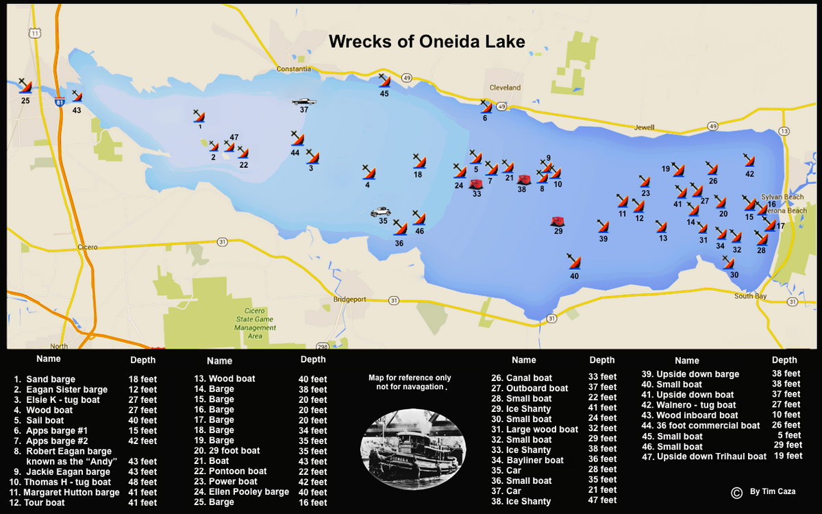
Oneida Lake, located ten miles north of Syracuse in Oneida and Oswego Counties, is the largest lake lying wholly within New York State. For many years the lake was an important cog in the state’s water transportation network. Hundreds of tugs and barges used Oneida lake to transport various goods. Because it was not uncommon for some lake transportation companies to push the seasonal limits, quite a few ships ended up on the bottom of Oneida lake. Currently, more than 45 wrecks have been discovered in the lake. Below you can find the chart with all known Oneida Lake wrecks (courtesy of Dennis Gerber, and Tim Caza at www.sonarguy.com).
As for the fish species present in the lake, you can find walleye, largemouth bass, smallmouth bass, chain pickerel, northern pike, tiger musky, bluegill, pumpkinseed sunfish, rock bass, black crappie, yellow perch, freshwater drum, common carp, bowfin, burbot, longnose gar, lake sturgeon, gizzard shad, and round goby.
Since zebra mussels entered the lake in the early 1990's water clarity has improved considerably. This has resulted in increased aquatic vegetation growth. Oneida Lake has very good weed growth, especially along the shoreline and in the larger bays. Vegetation is most abundant in 5 to 15 feet (1.5 to 4.5 meters) of water; however with the greater water clarity some vegetation may be found as deep as 20 feet.
Because it is shallow, Oneida Lake is warmer than the deeper Finger Lakes in summer.
Niagara River
Depth: Max. - 170 ft (52 m)
Average Visibility: 30 ft (9 m)
Niagara River is great for current diving. You can drift along at a depth of 20 feet while barely having to kick - the water does most of the work! Be ready for 5-knot currents though. Visibility of 30 feet (9 meters) is common with water temps in the 70's.
Don't be surprised if your dive buddies include walleye, sturgeon, and pike.
Last but not least, always have a float and flag, when diving the river, as you are in navigable waters, and don’t forget that you are not allowed to drift to Canada.